SLU
EAS-A193 Class Notes
|
SLU EAS-A193 Class Notes |
|
For a long time, difficulties in travel and communication limited the information available on earthquake damage and devastation. Most records of the oldest earthquakes record primarily the loss of life and economic damage. With advances in travel and communication, scientists were able to find out about and visit localities hit by large earthquakes. Some of the earliest observations involved the nature of the damage to Earth's surface and human constructions such as buildings, roads, etc..
Some Earthquake Damage Photos
Eventually, shaking intensity scales were developed to standardize the measurements and ease comparison of different earthquakes. Shaking intensity varied from barely perceptible to completely destructive. Since 1933, in the United States we have used what's called the Modified-Mercalli Intensity scale, a twelve-stage scale, numbered from I to XII. The lower numbers represent imperceptible shaking levels, XII represents total destruction.
![]()
A value of IV indicates a level of shaking that is felt by most people. An abridged version of the scale, based on the table in the back of Bolt's "Earthquakes" book, is located here.
Early in the study of earthquakes, intensities were assigned by scientists who traveled to regions that had recently experienced strong earthquakes. Throughout much of the 20th century, postal surveys were conducted to measure intensity. Recently, e-mail surveys have been used to map out the felt areas (click here to see an example).
In general, intensities are largest close to the earthquake and decrease with distance from the earthquake and thus provide a means of locating and comparing the size of shallow earthquakes. The best way of representing and interpreting intensity observations is to create an intensity map, a geographic representation of the distribution of ground shaking.
We call the lines separating regions of different shaking intensity isoseismals. The general location of the earthquake and regions likely to have experienced the most severe damage are also readily identifiable on the resulting intensity map. Here's an example from the 1966 Parkfield earthquake (Parkfield is located in central California).
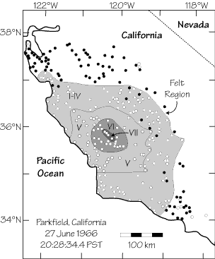
Intensity distribution observed for the 1966 Parkfield, CA earthquake. This earthquake had a magnitude between 5.0 and 5.3 and was felt over an area of approximately 20,000 square kilometers.
Although important and a successful approach to the early study of earthquake size, intensity has problems when we expand our study to earthquakes that are not located near reference structures or earthquakes that occur deep beneath Earth's surface.
For a fixed earthquake size, the region of strong shaking can be an indication of the regional geologic structure. A particularly illuminating illustration of the effects of regional geology on earthquake shaking is presented in Figure 0-2. The region of damaging shaking is shown for two earthquakes with roughly the same size - the 1811 New Madrid earthquake and the 1906 California earthquake. The precise magnitude of the 1811 earthquake is uncertain since we had no seismometers available to provide instrumental measures of the shaking but indirect estimates suggest that it was a great earthquake. The great 1906 San Francisco earthquake had a surface-wave magnitude of approximately 8.3. The late Dr. Otto Nuttli of Saint Louis University estimated the intensities for the New Madrid quake by studying the newspapers and personal journals which contained reports of the effects of the quake. Since the land west of the Mississippi was sparsely settled at the time, the region of shaking west of the earthquakes is inferred using the shape of the region in the east. The old, eastern section of the US transmits seismic vibrations very efficiently relative to the relatively young, warm California coastal region. These observations suggest that for an equal-size earthquake, the east is likely to experience a wider extent of damage than coastal California. We are fortunate that earthquakes are less frequent in the eastern half of the continent, but the eastern half of the country has grown dramatically in a time of no large earthquakes. The next large earthquake to occur in the east has potential to produce substantial loss of life and property.
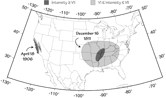
Regions with damaging shaking during the 1811 New Madrid earthquake (estimated magnitude somewhere between 7.0-8.0) and 1906 San Francisco earthquake (estimated magnitude 8.3). For the 1811 event, the shaking to the west of the Mississippi is estimated based on the observations to the east since the region was not yet settled (After Nuttli, 1981).
One aspect of intensity that is difficult to quantify is the effect of the near-surface geology on the intensity of seismic shaking. We call this effect a site effect because it is local to each site. Several physical parameters can affect shaking intensity. The primary control of the site response is the rock or soil type, and a secondary control is the water content. The "harder" the rock the lower the level of shaking is a good rule of thumb. Igneous rocks such as granite are considered a hard rock, soft rocks are usually sedimentary rocks which include limestone, shale, and sandstone. Relative to a granitic site, a site underlain by sedimentary rocks could experience an increase of one-half to two intensity levels at the same distance from the same earthquake. Sites underlain by young saturated soil or alluvium usually shake with the highest intensity&endash; relative to granitic sites they may experience up to a three intensity level increase in shaking.
Obviously if you are close to a large earthquake, you will know it. But whether or not you feel vibrations from a distant earthquake depends on a number of factors related to where you are and what you are doing. Most people will detect a level of ground vibration equivalent to approximately 2% of the acceleration of gravity (the acceleration of gravity, g = 980 cm/s^2). If you are in the upper stories of a tall building, you are more likely to feel the ground vibrate than if you are on the ground. If you are in a car, you are less likely to detect small vibrations than if you were walking along the same road. And psychological factors can enhance the experience: some people become very sensitive to vibrations after they have experienced a large shock. The aftershocks in an earthquake sequence can be quite nerve-wracking for those individuals.
The complications to the cause of strong shaking and perceptibility make using intensity as a direct measure of earthquake size difficult. The subjective nature of intensity measurements, their dependence on building practices, population distribution, earthquake depth, etc. lead seismologists to develop the magnitude scale, which is based on measurements from seismograms. However, in general, the level of shaking is largest for large earthquakes and the maximum intensity does provide useful information on earthquake size. A direct correspondence between the instrumental measure of earthquake size, the magnitude is impossible. However, some general rules of thumb for a crustal depth earthquake are possible even though they are unsuitable for detailed work.
Occasionally, large earthquakes rupture the surface and produce a complex region of intense deformation. For large events, this zone of "surface rupture" is much longer than it is wide, a direct consequence of the fact that large earthquakes are the result of slip along appreciable portions of a fault. The elongation of the intensity of shaking is also visible in intensity maps of shallow, moderate-size earthquakes. Carefully study the diagram of the 1966 Parkfield earthquake and you will see that the region of the most intense shaking was elongated in the northwest-southeast direction. The shaking was aligned with the trend of the San Andreas fault in that part of California. The effect is even more dramatic in the geometry of the shaking from the 1906 San Francisco earthquake. The zone of most intense shaking was located in a long, linear trend, parallel to the coast which followed the surface trace of the San Andreas fault from central to northern California. The other region of intense shaking further, located to the east, is the result of site effects in the soil-covered central valley of California (sometimes called the Great Valley).
The first clues to the role of faulting in earthquakes was developed in the late 1800's by geologists who studied the fresh surface rupture generated during earthquakes and linked the process with long-term surface deformation such as mountain uplift and stream offsets. We next turn our attention to some details of faults and faulting, which leads to some interesting classification of earthquake activity.