SLU
EAS-A193 Class Notes
Global Evidence Supporting
Plate Tectonics
Plate Tectonics
|
SLU EAS-A193 Class Notes |
Plate Tectonics |
To a first approximation, Earth is a composite of eleveated contintents and deep ocean basins. We use the present-day sea level to reference topography and bathymetry and the average elevation of the continents is 840 meters, the average depth of the oceans is 3800 meters. The maximum continetal elevation is about 8848 meters (Mt. Everest) and the deepest trench is about 10,000 meters (Mariana Trench).
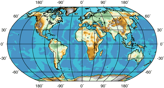
Present-day coastlines are outlined in black, but the margins of the continents are better approximated by the base of the continental shelf, which is often located at about 500 fathoms (about 900 meters). High continental elevataions are shown with gray and white, the lowest with green, and the browns are intermediate.The lightest blue shade corresponds to the shallowest part of the ocean floor, the darker blue shades identify deeper regions.
Following World War II, a great deal was learned about sea-floor bathymetry as governments supported exploratoration of the ocean depths. As a result of that work, the variety of structures in the ocean bottom were identfied and mapped, including a 40,000 km long ridge system that encircles the planet. The ridge system is identified in the map above by the light shaded regions near away from the continents.
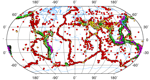
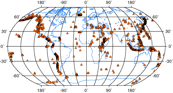
Earthquakes occur in the outermost 700-750 km of Earth and are located in well-defined belts of intense activity.
|
|
The map above shows the distribution of earthquakes with magnitudes greater than 5.0 that occurred between 1965 and 1995. The color of the symbol identifies the hypocentral depth and continent coastlines are shown in blue. Earthquakes deeper than 500 km are restricted to only a few regions surrounding the Pacific and part of the Indian oceans. Shallow earthquakes are located over much of Earth, but are most common in narrow belts. The intersections of the earthquake trends form triple-juctions, but never do four trends meet. The deepest earthquakes are located on the rim of the Pacific Ocean (those regions also have shallow earthquakes, but on this map their symbols are hidden beneath the deep events).
|
In the map below, each triangle represents the location of a recently acitve (on a geologic time scale) volcano. Note the well defined arcs such as in the Aleutians, central andwestern North and South America, and the east Pacific all of which correlate with the locations of deep earthquqkes. Some volcanic regions such as the Hawaiian Islands are isolated. An interesting region of susbstantial volcanic activity is east Africa, a region also experiencing extensional faulting.
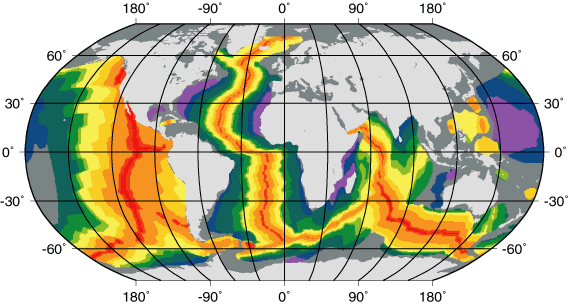
The youngest regions are shown in red (age < 2 Ma) and red-orange (age 2 Ma < 5 Ma), the older regions in orange, gold, yellow, green, blue, and violet. The ocean ridge system shows up as an interconnected ribbon of red and red-range indicating that the ridges are the youngest part of the oceans. Spreading is slower in the mid-Atlantic than along the east-Pacific. The original digital data are courtesy of researchers at the Scripps Institute of Oceanography).
We measure heat flow at different points on Earth's surface by measuring the change in temperature with depth (a higher temperature gradient indicates higher heat flow, assuming that the measurements were made in the same material). The map shown below is from the work of Pollack and Others (Reviews of Geophsyics, 1983). Variations in the heat-flow measurements were averaged to provide a mathematical representation of Earth's heat flow. Individual measurements in any region can be different from the values plotted, but the regional averages are well represented in the diagram.
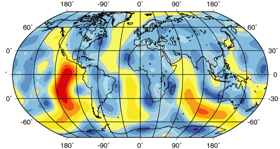
The average continental heat flow is about 57 milliwatts per square meters (mW/m^2), the oceanic heat flow is about 100 mW/m^2. The "warm" colors yellow-orange-red indicate higher than average heat flow, the blues are lower.
As you can see, the heat flow is greatest along the system of mid-ocean ridges. Further, the location of the high heat-flow regions correlates with shallow regions of shallow ocean depth (ridges on the sea floor) and the location of earthquakes.